

New high-resolution satellite imagery accessed on Friday has offered a closer look at the site of the breach near the high-altitude South Lhonak Lake in Sikkim, which led to devastating floods claiming the lives of at least 50 people. These images provide valuable information, including exposed portions of the lake’s banks, indicating a significant drop in water levels following the breach, resulting in massive floods downstream along the Teesta River basin.
One noteworthy observation from the satellite images is the presence of a possible landslide, which may have played a role in the lake overflowing. Arup R Dasgupta, Managing Editor of Geospatial World and an experienced ISRO imagery expert, pointed out that the glacier’s substantial snow cover could have exerted immense pressure on the lake’s snout, potentially leading to the breach.
Situated at a lofty altitude of 17,100 feet in the upper reaches of northern Sikkim, near the India-China border, the South Lhonak Lake has been at the center of attention since the tragic floods occurred. The images captured on Friday reveal the precise location of the breach, indicating that water continued to flow out of the lake three days after the breach initially occurred.
The reduction in the lake’s water level has exposed a significant portion of the shoreline that was submerged just days ago. According to Indian Space Research Organisation (ISRO) scientists, the lake’s size has diminished by more than half, leaving approximately 60.3 hectares of water within it.
The South Lhonak Lake received runoff from the retreating North Lhonak glacier and the primary Lhonak glacier, expanding its surface area by 500 meters and its average depth by 50 meters, as noted by Dr. SN Remya, the lead scientist of a 2013 study.
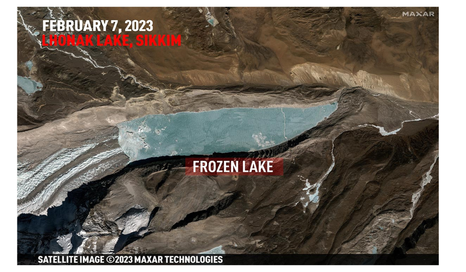
Comparing images from February, which displayed the lake as entirely frozen with visible surface fractures, to those from Friday, where broken ice and ice floes were apparent, suggests a significant change. It remains uncertain whether this change resulted from the flow of underlying water rushing toward the breach or substantial summer melting.
Mr. Dasgupta highlighted the regular fracture pattern on the ice cover in the initial images, possibly due to pressure from the glacier. Fresh snowfall on the glacier, as seen in the second image, could have exacerbated this pressure, potentially contributing to the breach.
Furthermore, the October 6 image shows clear evidence of a landslide on one of the South Lhonak Lake’s banks. Whether this landslide played a role in displacing water and contributing to the breach remains uncertain.
The region’s lake-terminating glaciers have exhibited accelerated growth in Sikkim, including the South Lhonak glacier, raising concerns about potential hazards, especially in densely populated downstream areas, as highlighted in a 2021 study published in the journal Geomorphology.
Sources By Agencies